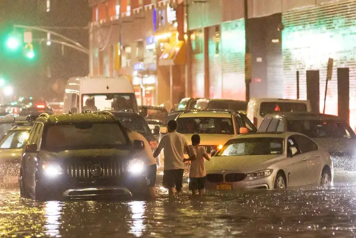
When the rains come, the corner of Carroll Street and 4th Avenue usually floods. Yet middle Brooklynites and Park Slopers were left stunned after the remnants of Hurricane Ida tore through New York City this week.
Viral videos showed cars slushing through floodwaters—against the advice of emergency officials—as the post-tropical cyclone dumped up to nine inches of rain over parts of the city and New Jersey. Camille Manzo, who works at the Neptune Machine shop near the corner of Carroll, said she had never seen the rain waters rise so high.
“It never came this far,” said Manzo, who lives nearby and experienced flooding at her house too. Down the street, Erica Goldman, who has lived in the neighborhood for four years, was trying desperately to dry out her minivan, which had filled with water all the way up to its cup holders.
“In the subway, [this flooding] seems like it’s frequent... A couple of times, it's been wild like that in the subway,” Goldman said while mulling over how to get puddles of water from beneath her stowaway seats. “The street [flooding] seems unprecedented... and Queens, out of control.”
In some ways, everyone saw Ida coming, and no one saw Ida coming. On Thursday, Mayor Bill de Blasio blamed weather projections for being inaccurate. Emergency declarations weren’t made until well after the storm hit the area with tornadoes and a deluge. But in truth, atmospheric scientists and weather forecasts had predicted between 10-14 inches of rain across much of the mid-Atlantic as early as Monday.
Atmospheric scientist Tomer Burg was one of several researchers and meteorologists who predicted and warned of Ida's devastating impact several days before the storm.
Tomer Burg via TwitterBut those messages failed to generate enough public concern to prevent tragedy. As of Friday morning, the flash floods had claimed more than three dozen lives across New York City and New Jersey—many lost when basement apartments became inundated. The cleanup and damage will cost untold sums.
Read More: City Allows NYC Residents To Pump Floodwater Into Streets During Cleanup After Hurricane Ida
The missed communications speak to an obvious trend. Despite lessons learned from Superstorm Sandy and billions spent on resiliency projects, the region still isn’t coping well with the wrath of severe storms and climate change. Experts say much of Ida’s flooding came from urban concrete sidewalks and asphalt roads funneling and pooling water—rather than having dirt and plants soak it up.
“A lot of the flooding you're seeing in the New York metro is in areas that are totally impervious,” said Dr. Adam Sobel, who leads Columbia University’s Extreme Weather Initiative. Local sewer systems are also not built to handle 3-4 inches of rain in a single hour. Newark has one of the most outdated stormwater systems in the country, leaving the Jerseyan city to flood during regular rainstorms.
Hurricane warnings also tend to focus on the threats to coastal regions or the dangers posed by wind speed. A Category 4 storm refers to one with 130-156 mile-per-hour gusts. Sean Sublette, a meteorologist with Climate Central, says the remnants of powerful storms, like Hurricane Ida and Hurricane Henri, need to be taken more seriously by officials and the public as they travel inland.
“How many people really get that?” Sublette said. “Sandy was water coming in from the ocean. What happened yesterday was water pouring down out of the sky. Both of these have names that people are going to remember forever, but how many people know or care about the difference?”
Part of the problem stems from how officials communicate uncertainty and how the public perceives those messages. The National Weather Service started Wednesday morning around 6 am by telling New Yorkers to watch out “for 3 to 6 inches of rain, with locally higher amounts possible.”
A second message about an hour later upped the concern by warning of ”significant & life-threatening flooding,” but still the rainfall prediction only spoke of “3-8 inches, with locally higher amounts.” The potential for life-altering floods was baked into those forecasts. But based on how many regular people were caught unawares, it’s safe to say those descriptions needed more oomph.
The mainstream alerts also could have emphasized that Ida was on a collision course with a northern cold front. When the two weather systems met, it caused Ida’s warm moisture to suddenly vault upward in the sky—a process called frontogenesis that typically leads to bigger downpours.
“We knew it was quite likely that they were going to be much higher totals somewhere. It just wasn't certain,” said Sobel from Columbia. “There's always some uncertainty in exactly where the band of the heaviest rain is going to be.”
Weather forecasts have improved dramatically over the past 30 years. Take storm paths as an example. As science reporter Alejandra Borunda reported last year for National Geographic, “by the time a storm makes landfall, the difference between its predicted and real locations is less, on average, than 8 miles.”
But even with that resolution, forecasts struggle to predict what might happen down at the neighborhood level, said Dr. Andrew Kruczkiewicz, a senior researcher for Columbia’s International Research Institute for Climate and Society, who studies flooding and disaster responses.
The dangers of that uncertainty become magnified during flash floods, Kruczkiewicz said, for two reasons. First, people tend only to act when the warning is big. Tell them to evacuate, and they’ll leave, but without strong messaging, they’ll go about their regular business.
On the flip side, Kruczkiewicz said elected leaders, weather officials and news outlets have also been criticized in the past for raising "false alarms," such as when New York City dodged the worst of Hurricane Irene in 2011. It's thought that a year later, fewer people took Superstorm Sandy seriously. Severe rainstorms, meanwhile, remain a huge blindspot to this day.
An intersection is flooded by more than 5 feet of water following torrential rains from the remanants of Hurricane Ida in Lodi, N.J., September 2nd, 2021
“Flash floods are a neglected hazard relative to other hazards,” Kruczkiewicz said, citing how local research and policy ramped up and focused on coastal storm surge in the wake of Sandy. “I hope it’s a wake-up call to prioritize these other types of flooding.”
He said the need is urgent because climate change will continue to worsen Northeast rainfalls over time. It was a point echoed by Sublette from Climate Central. Thanks to climate change, he said severe storms in our area produce 10 to 20% more rainfall than 60 years ago.
“It's just a little bit more, and it makes it that much more impactful and that much worse,” Sublette said. “It would've been bad anyway, but this just made it worse.”
At the same time, our fellow citizens and elected leaders continue to take risks when it comes to living in flood-prone areas. Due to its housing shortage, New York City loosened rules around basement apartments in 2018—in hindsight, a potentially dangerous move in a region facing more and more extreme rain. The city's rules for basement apartments don't mention any restrictions for flood zones.
“Has the number of basement apartments decreased since Sandy? Maybe that's a question we could ask ourselves?” Kruczkiewicz said. And as WNYC/Gothamist reported this summer, New York City hasn’t updated its flood zone maps since 2007, meaning tens of thousands of New Yorkers are in harm’s way and might not even know it.
“This wasn't just one neighborhood or two neighborhoods in New York City seeing a flash flood [warning],” Kruczkiewicz said. “This was a flash flood emergency, which is a whole different level.”
Emily Lang, Danny Lewis and Sean Carlson contributed to reporting.